How to Start Designing Residential Landscapes in AutoCAD
One of the most powerful softwares to use is AutoCAD - a versatile software widely used by professionals for creating detailed, precise drawings and designs.
If your new to AutoCAD, here is a comprehensive guide to learn how to start designing landscapes in AutoCAD.
1. Understanding AutoCAD’s Interface
When you're new to software, it's common to feel lost and unsure of where to navigate, as the interface and tools can be overwhelming.
Mastering AutoCAD's interface, including the Ribbon Bar, Command Line, and Model and Paper Spaces, boosts efficiency and precision in drafting plans and implementing design elements like vegetation and hardscapes.
Spend some time exploring these elements:
- Ribbon Bar - contains multiple tabs with various tools organized in panels. For landscape design, you'll frequently use the Draw, Modify, Annotation, and Layers panels.
- Command Line - allows you to enter commands directly, offering suggestions and options as you type.
- Model Space - this is where your design will take shape, surrounded by various palettes that you can customize to suit your workflow.
- The Paper Space - this section of AutoCAD allows designers to put their designs on standard size paper to print to PDF
2. Importing a Plat of Survey
Importing this document into AutoCAD can be challenging, as specific settings must be adjusted to ensure it loads correctly into the software.
To start with a Plat of Survey, you first must know if the Plat of Survey is Rasterized or Vectorized.
- Rasterized plat of survey is a scanned image of an older survey document, converted into a pixel-based format. These images are typically used for archival purposes but lack scalability and editability without further processing.
- Vectorized plat of survey consists of vector data, which are mathematical descriptions of shapes and lines created or exported from CAD programs. This format allows for easy editing, precise scaling, and integration with other digital design processes, making it ideal for modern engineering and architectural applications.
To import a Vectorized Plat of Survey:
- Type the command “Import” into AutoCAD
- Click on the PDF Import button. A dialogue box will open.
- Browse and select the PDF file you wish to import.
- Click Open to proceed to the import options.
- Choose the page: If your PDF has multiple pages, select the page that contains the plat of survey.
- Specify the data to import: Check options for importing geometry, fills, raster images, and TrueType text as needed.
- Choose the insertion point: Opt to specify an insertion point or use the default setting.
- Click OK to start the import process.
3. Designing Using Basic Commands
As a newcomer to AutoCAD, the interface may seem confusing. To simplify, start by typing commands directly into model space. This workflow allows new designers to focus on creating without the need to navigate the interface, leading to quicker design execution.
With the plat of survey in place, you can start designing by using basic AutoCAD commands to draw the layout of the landscape:
- PLINE command to draw boundary walls and fences.
- RECTANGLE and POLYGON tools can help outline patios, walkways, and garden beds.
- CIRCLE and ELLIPSE are useful for designing rounded elements like ponds or curved paths.
This foundational knowledge allows for quick modifications and additions, enabling designers to easily experiment with different configurations and respond to client feedback.
Furthermore, using these basic commands ensures consistency and accuracy across project documents, which is essential for seamless construction and installation processes. Thus, the ability to skillfully use AutoCAD's basic commands enhances the overall effectiveness and professionalism of landscape design projects.
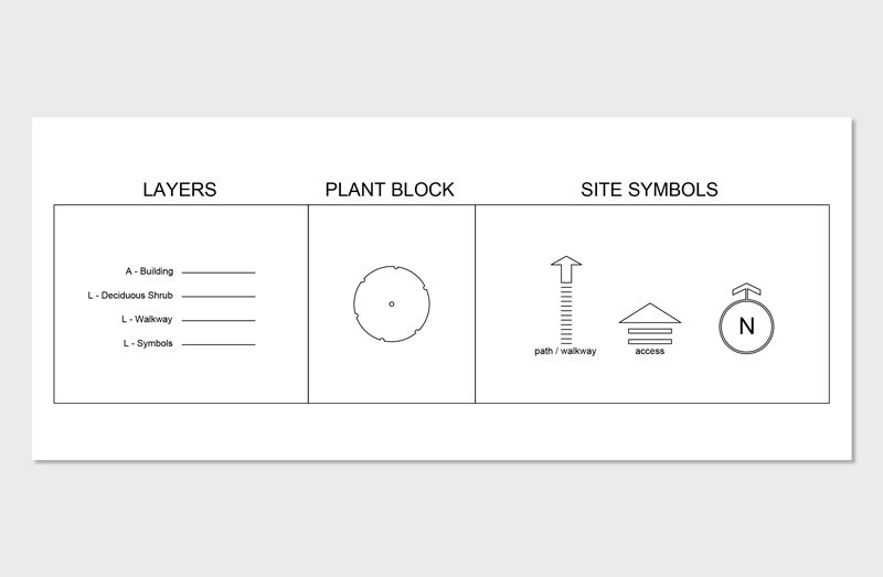
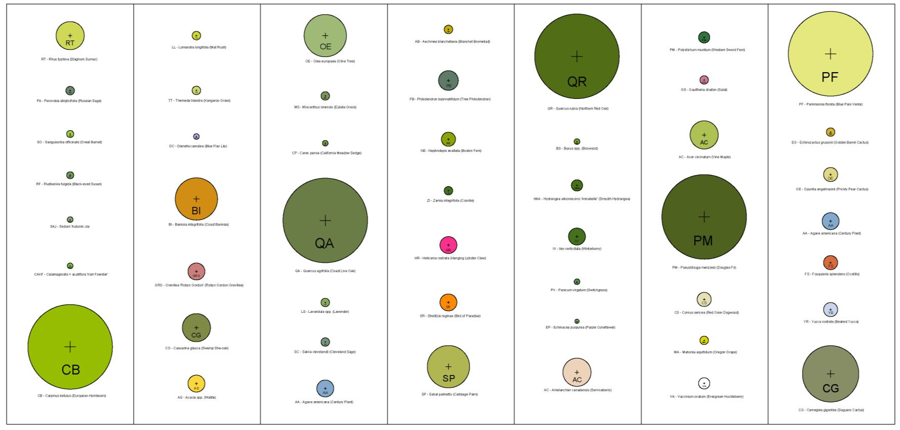
4. Creating and Using Plant Symbols
With this said, designers must create plant symbols from scratch to represent different types of vegetation:
- Draw a Circle: Start by drawing a circle to represent the boundary of the plant.
- Add Crosshairs: Insert crosshairs at the center of the circle to denote the center of the plant.
- Create a Block: Type BLOCK in the command line to initiate the block definition process.
- Name the Block: Assign a unique name to the block, ideally the name of the plant, to easily identify it later.
Making a custom plant symbol allow designers to represent various species with unique icons, making it easier to visualize and differentiate the vegetation planned for a site.
This standardization helps in communicating clear, concise, and attractive landscape plans to clients, contractors, and regulatory bodies.
Additionally, using these symbols can significantly speed up the drafting process, as they can be reused across multiple projects, ensuring consistency and reducing the time needed to create new drawings from scratch.
5. How to Learn AutoCAD for Landscape Design
AutoCAD is a powerful tool that offers precision and flexibility, crucial for detailed landscape design. It allows designers to create intricate layouts, adjust plans easily, and ensure that every element is perfectly placed.
What Our Course Offers:
Our course is designed to help you navigate and master AutoCAD's robust features with a focus on landscape design. Here's what makes our course unique:
-
Pre-loaded Layers: Start designing right away with pre-loaded layers tailored for various landscape elements, saving you setup time and streamlining your workflow.
-
Pre-built CAD Plant Symbols: Access a comprehensive library of CAD plant symbols that can be easily integrated into your designs. This library helps in visualizing garden layouts and selecting the right plants for the right place.
-
Step-by-Step Training: From the basics of the interface to advanced design techniques, our course covers everything. You’ll learn how to import survey data, manipulate terrain, and place hardscape materials efficiently.
-
Practical Design Exercises: Apply what you learn through hands-on projects that challenge you to think creatively and technically.
-
Expert Guidance: Learn from experienced professionals who provide insights and tips that are invaluable to becoming proficient in landscape design with AutoCAD.
Who Should Enroll?
This course is perfect for anyone interested in landscape architecture, from students who are just starting out to professionals looking to refine their skills.
By the end of our course, you will be able to efficiently create and modify detailed, accurate landscape designs using AutoCAD. You'll gain not just technical skills, but also an understanding of how to approach landscape design projects with confidence.
Enroll Now and Transform Your Landscape Design Skills
Ready to take your designs to the next level? Join our course today and start creating beautiful, sustainable, and functional outdoor spaces with AutoCAD. Whether you are looking to improve your professional skills or embark on personal landscape projects, our course is the gateway to mastering landscape design with AutoCAD.

The Landscape Library Academy is the education division of The Landscape Library.
Click here to visit TheLandscapeLibrary.com for media including education articles, projects features and more.
Company
Learn